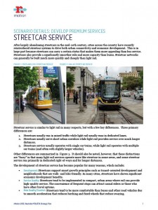
Streetcars have recently been deployed to drive urban connectivity and economic development because they provide a smoother ride and higher capacity than buses, but can generally be built much more quickly and cheaply than light rail. Streetcars typically operate on embedded rails in mixed-traffic lanes, so speeds tend to be lower than transit that operates in exclusive rights of way like bus rapid transit (BRT) and most light rail transit (LRT). However, certain design and operational features, like level boarding stations, prepayment, exclusive rights of way and center-lane alignments, can allow streetcars to match or exceed speeds found in LRT and BRT systems.
Streetcars fall into three categories:
- Urban Circulators feature local service and operate along lively streets with many stops.
- Streetcar Local Transit features higher speeds and can operate along arterial streets.
- Streetcar Rapid Transit provides wider stop spacing and use of exclusive travel lanes and signal priority.
Should Nashville MTA/RTA consider developing streetcars? Would you be more or less likely to ride a streetcar than a bus or train? Where should Nashville MTA/RTA consider adding streetcars? What are your thoughts?
As mentioned in my comments in Scenario 3 (may preferred alternative with the addition of Light Rail and Streetcars) I think the implementation of Streetcars in Scenario 1 leaves a lot to be desired.
Streetcar to downtown: There appears to be ample evidence for Streetcars as a development incentive (with rezoning). There is also plenty of evidence that streetcars are slow, 7mph, and DO NOT do much for tourism development. So, you WOULD NOT put a streetcar in your heavily traveled arterial, where development has already occurred, and into your historic tourism district. Streetcars carry your car-free workforce from high density living to high density office and commercial.
I think that two streetcars routes on Church/Woodland Streets and on 3rd Ave from the fairgrounds to Metro Center can make sense. Again, see the map at https://www.google.com/maps/d/edit?mid=zA-2xUZ–COU.kc23KZ3N_q_4 The routes on the map can be clicked off and on to show just the Streetcar routes.
The Church/Woodland Street route would originate at a Transit Hub at 34th and West End (a Walgreens is there now) and avoiding West End (remember the AMP?) cut across the front of Centennial Park to Elliston, then Church, over the new bridge across the gulch (stop requires an elevator), to 3rd (thereabouts) up to Union, then the Woodland Street bridge (consider a multilevel parking garage between the bridges, then along Woodland past Five Points. This route is primo for redevelopment and does not aggravate congestion on any major route.
The second Streetcar route originates at the Fairgrounds (itself a destination or a redevelopment opportunity), travels north on Rains, over the CSX railroad tracks to 3rd Ave, when you get to the Interstate access road and Lafayette do not go to 2nd but travel down to Lafayette, cross under Interstate 40 then up the other side to 3rd Ave at Lindsley.
view south at Lafayette: https://goo.gl/maps/YavEGaMcad52
view north at Lafayette: https://goo.gl/maps/bM8MpSTUVkS2
Continue north on 3rd Ave, continue through downtown, go under the CSX railroad on 4th Ave, to alongside the greenway at the Sounds stadium to 3rd (or optionally to 2nd to cross under Jefferson), continue on 3rd to Metro Center, terminating at Athens Way and Great Circle Road.
Both of these routes open up prime development opportunities (with rezoning), minimize disruption to major arterials, are well suited for downtown commuters who choose to live close, and is well suited for Streetcar service.
I think this is much, much better than the nMotion proposal.
Roy Wellington
Something broke along the way in the link in the message above. Replace the long dash with two hyphens.
Try this url:
https://goo.gl/kxX0ZH
Roy